National Park Access Free

2014 National Park "Free Entry" Dates!! January 20th Martin Luther King Jr. Day; February 15-17th Presidents Day weekend; April 19-20th opening weekend of National Park Week; August 25th National Park Service Birthday; September 27th National Public Lands Day; November 11th Veterans Day

Sunday, November 30, 2014

#47 - Old Company Mill - Raleigh NC


We were off to Raleigh, NC for Thanksgiving, and with the day full of food and football - followed by a day of Christmas "browsing", coffee's and deserts - Saturday made for a perfect day for a nearby 6.5 mile hike on the Old Company Mill Trail.

Company Mill was built on the banks of Crabtree Creek in 1810 when this land was farmland. The mill ground wheat into flour and corn into cornmeal - and was even known to host a fish fry or two or a square dance.

My two sons joined me on the hike, and its always nice to get out and do some things together.


The trail was in a wooded area, the air crisp and clear, as we made our way down to the creek to begin our loop. I'm always amazed how land that was cleared for farms, grows back to woodlands once the farming operations stop.

We crossed Crabtree Creek, then following the creek for awhile, cut inland and up. The trail was marked as moderate, and we found that to be an accurate description - and perfect for what we wanted to do this day.


We passed through areas of pine, crossed small streams, and enjoyed the peacefulness of the morning as the sun broke through, casting shadows and warming the day from 33 degrees when we started, to 50 when we finished.


We completed the loop, working our way back to the creek and the remnants of the old mill.


The perfect trail for the perfect morning. A good hike, fresh air, the ability to see something new - and a morning spent with my two sons. I could hike forever with them, sharing stories and laughs. There will come another time soon.


Keep hiking, friends!

Thursday, November 27, 2014

#46 - Culpeper, VA

Culpeper Visitor Center
With the Holiday's around the corner, getting out and about some of the small towns in the area makes for a beautiful day hike - with the added benefit of finishing up with window shopping, local bakeries, coffees, beers and food! But how to map out a route can sometimes become a challenge. Enter the Virginia Volkssport Association!

Recalling the days when we would volksmarch in the local communities of Germany, the Virginia Volkssport Association organizes walks, bikes, and swims that are non-competitive, going at your own pace. Normally done as part of a group, Culpeper was laid out as a "do it yourself" volksmarch with 5K and 10K options. Bonnie and I completed the 10K (6.2 mile) portion.

Starting at the Visitor Center, our hike started in the center of town, but quickly headed to the outskirts, allowing us to see sights we otherwise would have possibly by-passed.


As we made it to the outskirts of town, we were very surprised to find that Culpeper had a National Cemetery to honor their veterans. We saw graves sites dating back to the Civil War. It was very neat, clean, and you could tell an area of great pride.


From here, we headed through the historic residential area, with large homes resting on beautiful lots. A beautiful day, enjoying the sights and fresh air.


We skirted back around the center of town, taking in the sights, as we headed toward the nearby Yowell Meadow Park.


The park had a nice path ~ 2 miles long, following along Mountain Run, which was the town's water source years before.


All of this offered us a nice glimpse of the town that we would have never seen had we stayed in the historic district. It made us realize even more what a nice community Culpeper is. A prideful community, taking care of each other, making good decisions on how they want their community represented.

We headed back into town, finishing up our hike. Picking up some goodies at the local baker, enjoying oysters and craft beer at a local restaurant.


Raw Bar :-)
It is easy to say we "Love" Culpeper, and have plans to visit again soon! We also enjoyed the do it yourself volksmarch and plan to see what else they have to offer.


Happy Holidays - and keep hiking, friends!

Saturday, November 22, 2014

#45 - Chancellorsville - and the end of Thomas Jonathon "Stonewall" Jackson


Unless your last name is Jackson, or Hooker, Chancellorsville Battlefield may not resonate with everyone. Compared to Gettysburg, Antietam, and Manassas, it is not one of the more well known Civil War locations. Bonnie and I visited last Sunday, taking advantage of the looped paths traversing the nearby woods and fields, offering us a nice six mile hike.

Interestingly, this is the location where "Stonewall" Jackson was shot by friendly fire, resulting in having an arm amputated He died eight days later. Shot in one location, buried in another; his arm is buried in another location still. More on that soon.

The hike itself was great! The path starts where a monument marks where Jackson was shot (see above), and a grave of an unidentified Civil War soldier nearby. It quickly heads into woodlands, where aging earthworks remain and wilderness made for difficult and gruesome battles.


Earthworks are difficult to make out in the fallen leaves, where troops would lay in the trenches exchanging fire.

The wooded paths traversed rolling hills, which lead to the open battle fields ahead.
Wilderness: gruesome battles, fires, the screams of those left dying

The woods open up to fields, and farms. In all of the battlefields I have hiked, it is the story of the farm families that make me pause. These were people leading their lives in relative obscurity, until the soldiers came, taking over the farm home; the residents lucky if they escaped with their lives. Rarely did their house and belongings remain.

In fact, Chancellorsville is not a town at all. It was the Chancellors farm (though a very large farm compared to most.) As it was at a crossroad, it came to be known as Chancellorsville.

The Chancellors Farm: aka Chancellorsville

The remains of Chancellorsville


So, here you had the Confederate General "Stonewall" Jackson (under the leadership of Robert E. Lee), at battle with Union General Joseph Hooker. While Hooker had seen some successes earlier in the Civil War, he was not very successful in Spotsylvania, being pushed back North across the Rappahannock river.

However, it was during a battle with Hooker's forces, on May 2, 1863, when Jackson was wounded by his own men at the Battle of Chancellorsville. With two bullet wounds to his left arm and one to his left hand, he was taken to nearby Wilderness Tavern where his arm was amputated.

Robert E. Lee, upon hearing of the amputation sent a young Staff Officer to send a message, “Give him my affectionate regards, and tell him to make haste and get well, and come back to me as soon as he can. He has lost his left arm, but I have lost my right.”

Eight days later, on May 10, 1863, Jackson died near Guiney Station, about 30 miles from Chancellorsville. He died not from his injuries, but from pneumonia. He is buried in Lexington, Virginia.

"Stonewall" was given his nickname by Union General Bernard Bee at Manassas on July 21, 1861. Because of Jackson's steadfastness and demeanor, Bee said to his troops, "Look, men, there is Jackson standing like a stone wall! Let us determine to die here, and we will conquer!"
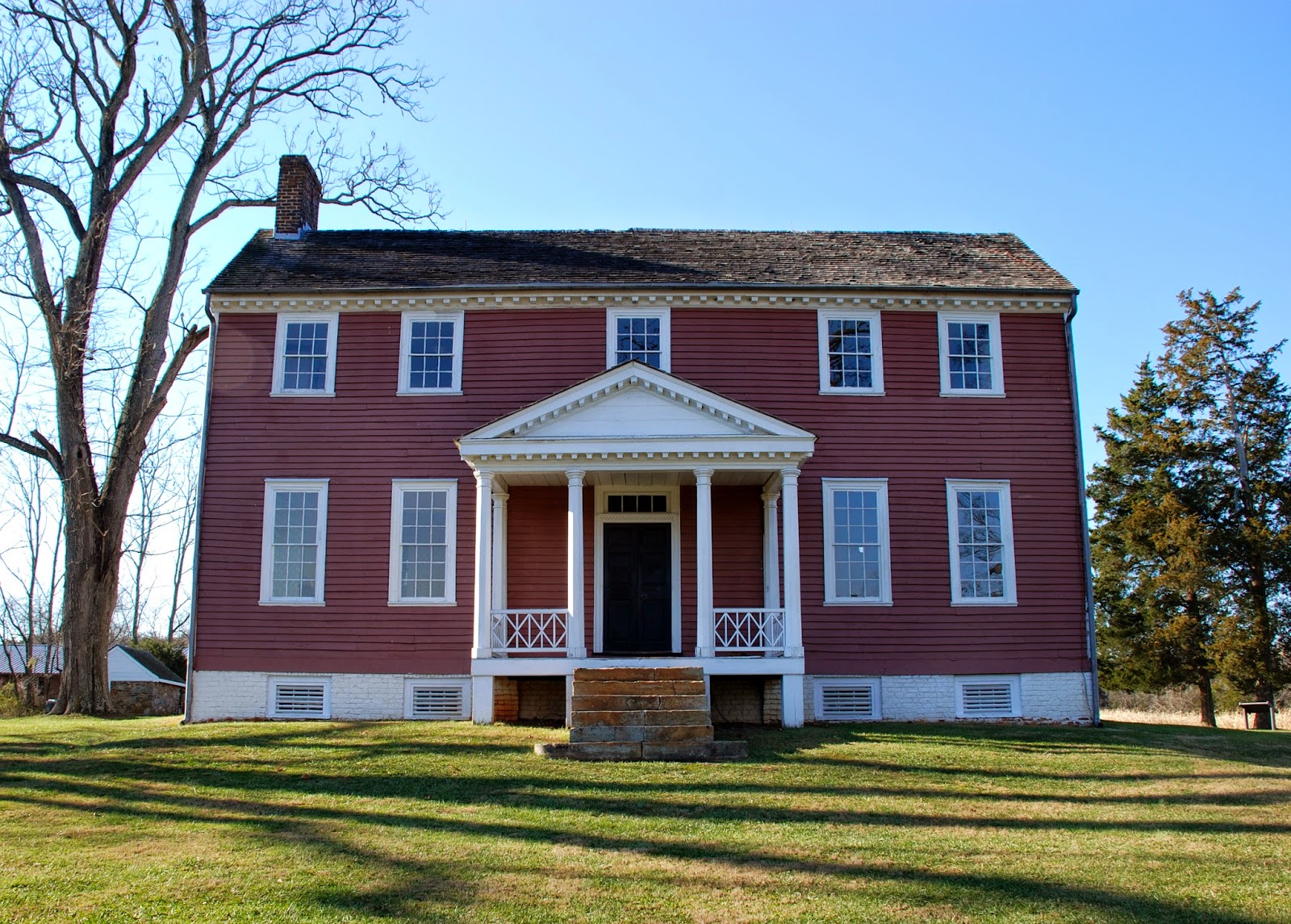
So, where's the arm? Unbelievably, after Jackson's arm was amputated, his chaplain, Beverly Tucker Lacy, took the arm to his brothers farm, Ellwood Manor, which was just nearby. Stonewall Jackson's arm is buried in the family cemetery there.


Hiking is many things. Much needed exercise, a sense of exploration, a time to think, a time to learn. Never did I ever think I would come across a grave site with the arm of Thomas Jonathon "Stonewall" Jackson.

Keep hiking, friends!